Learning from Metro Manila: How emerging metros risk repeating old planning failures (and how to avoid them)
The era of the "lone city" is fading, replaced by the rise of the metropolis, a sprawling, interconnected organism that transcends traditional administrative borders. This shift toward metropolitanization represents a global recognition that economic gravity no longer pulls toward a single downtown but instead circulates through regional clusters that function as a single, massive ecosystem. In this new geography, success is no longer defined by how well a city manages its own, but by how effectively it orchestrates the flow of people, data, and resources across an entire region.
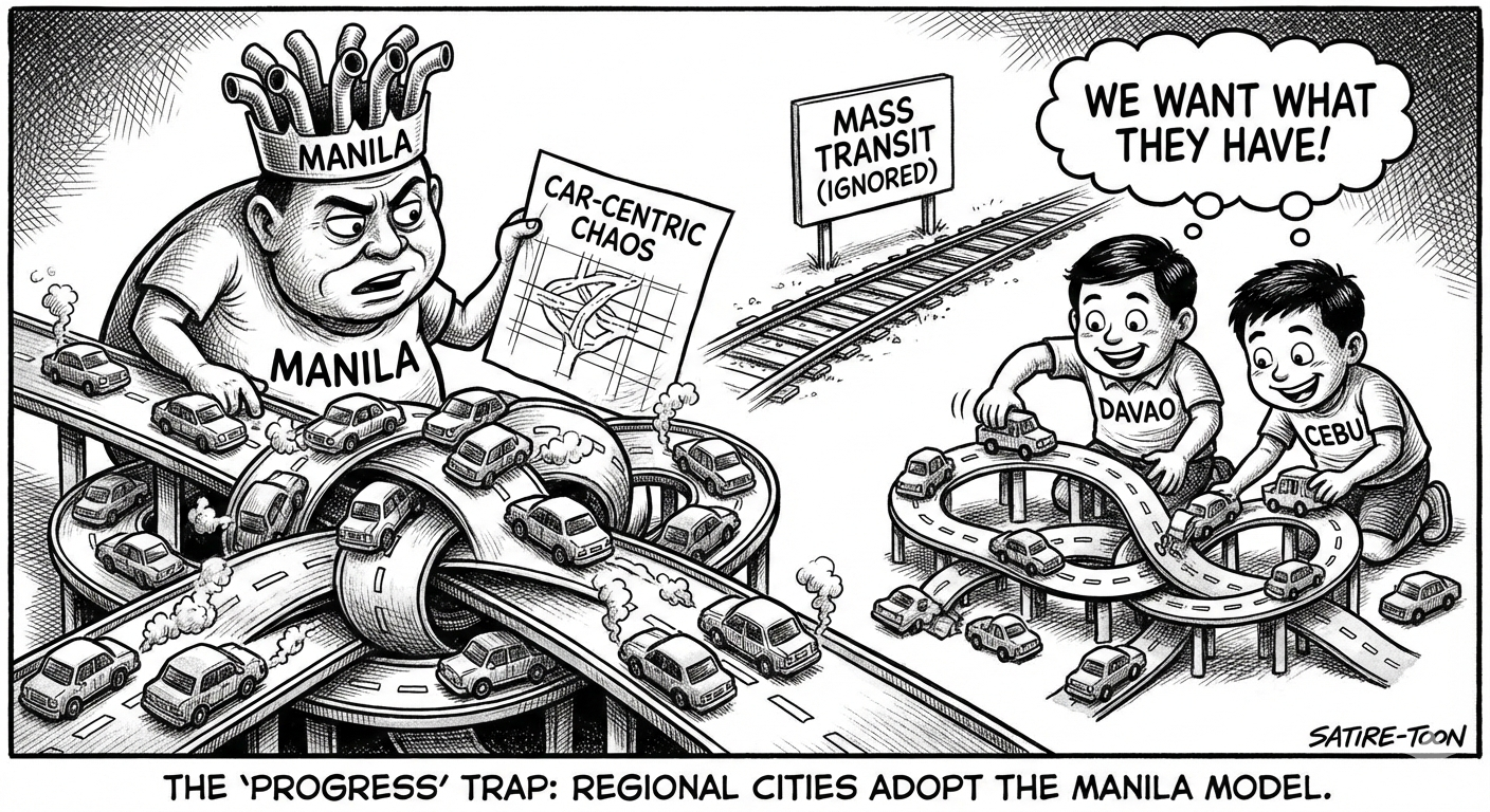
In the Philippines, development is now pulling away from saturated Metro Manila and toward regional hubs like Metro Cebu, Metro Davao, and Metro Cagayan de Oro. While this "next-wave" growth is vital for national resilience and sustained economic development, there is a growing concern that these emerging metropolises are speed-running the same structural mistakes that turned Metro Manila into a cautionary tale.
Early spatial and infrastructural patterns taking shape in these metros suggest that many of the conditions that shaped Metro Manila’s long crisis are already being reproduced. This trajectory is neither unique nor inevitable. Comparative experience from Jakarta, Bangkok, and Singapore also shows that while metropolitan dysfunction is common across rapidly urbanizing Southeast Asia, so too are credible pathways toward more resilient and coordinated urban development.
Structural roots of Metro Manila’s crisis
Metropolitan regions rarely fail because they lack plans. They fail because plans are treated as aspirational documents rather than binding instruments, and because urban growth repeatedly outruns institutions designed to manage it. Nowhere is this clearer than in Metro Manila.
Problems hounding the country’s primate metropolitan area did not arise suddenly, nor can they be attributed solely to population growth. Various studies consistently point to four interacting drivers: decades of permissive land use decisions, fragmented governance, car dependent transport investment, and systematic neglect of environmental systems have produced a metropolis defined by chronic congestion, recurrent flooding, and escalating climate vulnerability.
The most consequential of these has been permissive land conversion in environmentally critical and hazard prone areas. Floodplains, esteros, and wetlands that once absorbed seasonal flows were systematically built over, while hazard maps functioned as advisory rather than regulatory tools. The result was a city increasingly dependent on pumping stations and floodwalls to compensate for the loss of natural storage, a pattern well documented after successive flood events in the Pasig–Marikina basin and the Caloocan-Malabon-Navotas-Valenzuela (CAMANAVA) subregion.
Governance compounded these vulnerabilities. While Metro Manila has a coordinating body called the Metropolitan Manila Development Authority (MMDA), its authority over land use and local investment decisions remains limited. Each city and municipality comprising the metropolitan area pursue parallel development agendas, often competing rather than coordinating, producing piecemeal infrastructure and spatial mismatches between transport, housing, and employment. Transport investment followed a predictable path: repeated road expansion in the absence of early, high capacity public transport, locking in car dependency that proved both costly and politically difficult to reverse. Environmental infrastructure (i.e., drainage, wastewater treatment, and solid waste systems) was consistently treated as secondary to visible transport projects, despite mounting evidence that its neglect magnified flood and public health risks.
What is striking is how closely emerging Philippine metros mirror these early Metro Manila dynamics.
Metro Cagayan de Oro: Structural limits vs. urban form
Cagayan de Oro City, the hub that forms a budding metropolitan area to include Bukidnon and Misamis Oriental, presents a similar case, sharpened by disaster memory. After Typhoon Sendong in 2011, a JICA post‑disaster assessment highlighted extensive settlement along riverbanks and floodplains as a critical factor in the scale of loss. Yet more than a decade later, evacuations along the Iponan and Cagayan rivers remain common during heavy rainfall, despite substantial investment in flood control works. Structural interventions, such as the construction of dikes and flood walls, have reduced risk in some reaches, but they continue to operate within an urban form that places housing and commerce directly in harm’s way.
The metro's transportation strategy mimics Manila's early failures by focusing on "ribbon development" along major arteries without establishing a parallel mass transit spine. While the Mindanao Transport Connectivity Improvement Project (MTCIP) aims to improve regional links to Davao and General Santos, internal city mobility remains hampered by a lack of signalization and a "jeepney-first" logic that lacks the efficiency of modern rapid transit.
Metro Cebu: Fragmentation and the transport crisis
In Metro Cebu, the crisis is defined by governance fragmentation, a direct mirror of the "17 political wills" problem in Metro Manila. While the Cebu Bus Rapid Transit (CBRT) was intended to be the first of its kind in the country, the World Bank recently flagged the project as "unsatisfactory," which is attributed to unresolved right-of-way issues and institutional friction between 13 different local government units as primary barriers to completion.
Cebu is replicating Manila’s mistake of allowing urban sprawl to outpace infrastructure. Despite a daily economic loss of P1.1 billion due to traffic, the region continues to struggle with coordinating a unified land-use and transport policy, often settling for reactive "prestige projects" like subways and flyovers instead of integrating the existing fabric of the city into a cohesive TOD network.
Metro Davao: The cost of disappearing wetlands
In Metro Davao, anchored on Davao City, research shows the near‑total conversion of urban wetlands, approximately 95 percent lost since the mid‑twentieth century, primarily to residential and commercial uses. These wetlands once acted as seasonal retention areas for a city crisscrossed by rivers and estuarine systems. Their disappearance has coincided with increasingly frequent urban flooding, even during rainfall events that would once have been absorbed. Flood narratives from recent years confirm that the problem lies less in rainfall intensity than in lost storage capacity and drainage constrained by built form.
Beyond its environmental vulnerability, Davao City is now facing a mobility crisis that has seen it officially "dethrone" Manila in terms of congestion. According to the 2025 TomTom Traffic Index, Davao ranked as the most congested city in the Philippines and 12th worldwide, with an average congestion level of 66.2 percent, surpassing Manila’s 57 percent.
Davao appears to be meticulously replicating the "Manila Model," a car-centric blueprint that prioritizes massive road infrastructure, such as the Ulas Flyover Viaduct and perpetual road widening, over immediate mass transit interventions. This strategy triggers induced demand, where adding road capacity simply invites more private vehicles, much like the historical failures of EDSA. By the time the Davao Public Transport Modernization Project (DPTMP) reaches full operation (targeted for 2027), the city may already be locked into a structural gridlock where fragmented jeepney routes and a "door-to-door" culture have made transit-oriented development (TOD) nearly impossible to retroactively apply.
Choosing a different path
For emerging Philippine metros, the relevance of these comparisons lies in timing. Metro Cagayan de Oro, Metro Cebu, and Metro Davao remain at a stage where urban form is still malleable, and institutions can be strengthened before dysfunction becomes entrenched.
Three lessons stand out. First, land use plans must operate as binding risk management instruments. Development in floodplains, wetlands, and watershed protection zones cannot continue to be justified as economic necessity without accounting for long term public cost.
Second, metropolitan governance must evolve beyond voluntary coordination. While a stronger metropolitan governance system demands amending Article X, Section 11 of the Constitution, measures such as strengthened development authorities or binding inter LGU agreements should be adopted to align infrastructure and land use decisions across cities and municipalities within the metropolitan area at the scale where impacts are felt.
Third, public transport and environmental infrastructure must be front loaded rather than retrofitted. Early investment in transit and water systems is invariably cheaper and more effective than late correction.
Conclusion
Metro Manila’s trajectory offers no mystery. Its current condition is the cumulative outcome of choices made when urban growth outpaced institutional capacity and environmental limits were treated as negotiable. Emerging Philippine metros now face an unusually clear warning. The question is not whether Metro Cagayan de Oro, Metro Cebu, and Metro Davao will grow. They will. The question really is whether this growth will lock in the same long term liabilities that Metro Manila is still struggling to manage. ###